
Lorestan Earthquake
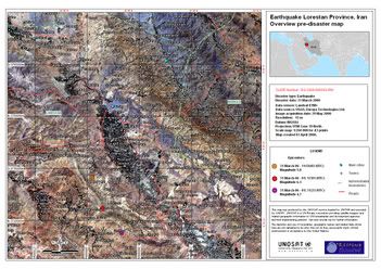
Mosaic of Landsat satellite images derived map showing the Lorestan Province before the Earthquake of 31 March 2006.
Images Acquisition date: 29 May 2000
Disaster date: 31 March 2006
Map created: 03 April 2006
Satellite image: Landsat TM+, USGS
GIS data: Europa Technologies Ltd
Map production: UNOSAT
Images Acquisition date: 29 May 2000
Disaster date: 31 March 2006
Map created: 03 April 2006
Satellite image: Landsat TM+, USGS
GIS data: Europa Technologies Ltd
Map production: UNOSAT
Iran - Mosaic of Landsat satellite images derived map showing the Lorestan Province before the Earthquake of 31 March 2006.
Images Acquisition date: 29 May 2000
Disaster date: 31 March 2006
Map created: 03 April 2006
posted by Thaqalain | Sunday, April 09, 2006
![]()
0 Comments:
Post a Comment
Subscribe to Post Comments [Atom]
<< Home